The value of 3D geological ground modelling, especially in enhancing characterising of sites and effectively communicating subsurface site conditions, cannot be overstated.
“A visual representation of the site conditions can often be worth a thousand words,” said Booyens. “These models should in fact be considered as powerful data management tools, especially as they can be updated as and when new information becomes available.”
His presentation, titled 3D Geological ground modelling: Practical examples of tailings storage facility footprint investigations, was delivered as part of SAIEG’s seminar series on Engineering Geology in Practice.
It pointed to the importance attached to site characterisation by the Global Industry Standard on Tailings Management (GISTM) – not just during the various design stages but throughout the life cycle of the TSF. He said the engineering geologist plays a critical role in ensuring that adequate characterization of the ground profile is conducted.
“Our discipline ensures that all geological and geotechnical aspects are sufficiently addressed and presented, so that design engineers have a thorough understanding of the site conditions,” he explained.
Engineering geologists typically conduct various levels of geotechnical investigations, in line with the South African Institution of Civil Engineers (SAICE) Site Investigation Code of Practice. These investigations take place at different stages of a project life cycle, from pre-feasibility through to post-construction and even remedial stages.
“I would recommend working on a 3D model prior to the construction of the TSF,” continued Booysens. “This helps design engineers to understand not only the underlying ground conditions, but also informs them on the larger scale geomorphological setting of the site.”
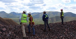
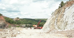
Using the example of a recent TSF project on a South African platinum mine, Booyens highlighted the critical importance of as-built drawings and surveys in elements such as the foundation footprint preparation and the starter wall foundation excavations. Logging and inspections along open excavations was also critical, as a larger exposure of the underlying material provides invaluable additional insight into the site conditions.
This example illustrates another valuable 3D model benefit. By allowing the engineering geologist to work effectively with all available data, they are better able to identify any gaps; these gaps then guide the planning of future investigations, which can focus on the identified areas of interest.